What a Land-Use Plan Actually Organises
See how a land-use plan groups activities, guides development decisions and gives a growing district a framework without settling every proposal.
A land-use plan organises which activities may be considered in different parts of a place, and how those decisions relate to one another. It does not usually approve a building proposal by itself. Its more modest task is to establish a shared framework: where homes, shops, workshops, parks and civic uses might fit, and what questions a later decision must address.
That distinction can sound technical until a district changes. A vacant depot becomes a housing proposal; a strip of shops attracts requests for flats above the ground floor; a small manufacturer needs room to expand. The plan gives public officials, residents and applicants a common map for discussing those changes without treating every parcel as an isolated argument.
A district in transition
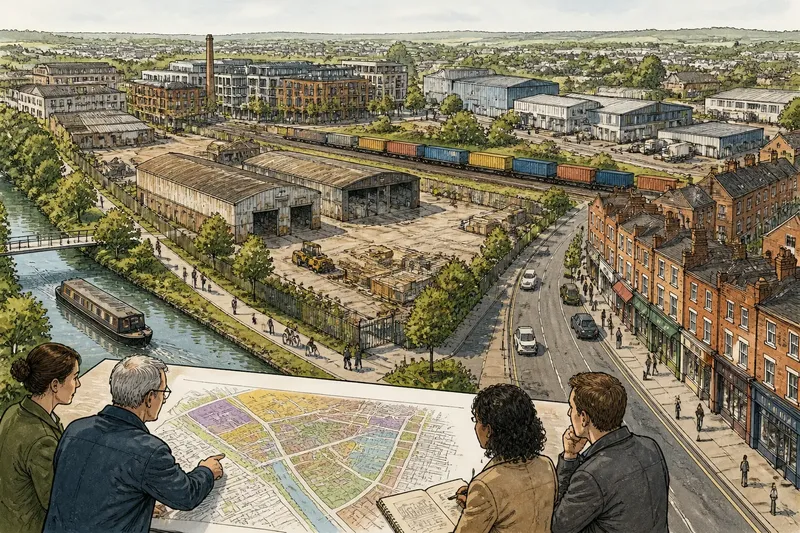
Imagine a clearly hypothetical place called Alder Quay. It has a former freight yard beside a canal, a row of older houses, a high street with small shops, and a light industrial area beyond a railway line. The council expects applications for new uses, but no single proposal has yet been approved. Its task is to prepare a land-use plan that gives future decisions a coherent setting.
The starting point is not a list of buildings to be built. Planners first describe what is already there and how the parts work together. They note where homes sit, which streets carry commercial activity, where goods vehicles need access, and which open areas connect to the canal. This inventory is useful because two sites that look empty on a map may have quite different roles: one may be a former yard with road access, another a green route used to reach the water.
Alder Quay’s plan then groups land by broad activity and purpose. The high street might be identified for mixed use, where shops, services and homes can coexist. The freight yard might be marked for redevelopment, with housing and workspace considered subject to access and environmental questions. The industrial area could remain a place for production and storage, rather than being treated as spare land simply because nearby housing is attractive.
Groups, not building scripts
These categories are a way to organise choices, not a script specifying the exact design of every site. A plan can indicate that a district is suitable for a broad family of uses while leaving later decisions to assess a particular proposal. The line between those stages matters. A plan may support the idea of homes on the former yard, but an application still needs to show how its layout, access and relationship to nearby uses would work.
Land-use categories also help expose conflicts early. A new workshop might bring jobs and services, yet its deliveries could share a narrow street with school journeys. Homes near a busy commercial frontage may benefit from nearby shops, while requiring attention to noise and servicing. The plan does not make these tensions disappear. It gives decision-makers a place to name them and to ask whether the proposed arrangement is suitable.
Think of the plan as a set of labelled drawers rather than a finished model. The labels help sort decisions, but they do not dictate the contents down to the last object. A category that is too broad can hide important differences; one that is too narrow can make ordinary changes awkward. The useful level of detail depends on what decisions the plan is meant to guide.
From map to decision
At Alder Quay, the council’s draft map shows the former freight yard as a mixed-use opportunity area. The accompanying policy text says proposals should consider access to the canal path, links to the high street, and compatibility with the neighbouring industrial area. Those words connect the map’s broad designation to questions a future application can answer.
Now imagine a developer proposes homes, a small food shop and shared workspace on part of the yard. The proposal is not accepted merely because the plan mentions mixed use. Officials would consider whether the mix fits the plan’s aims, whether the site can be reached safely, and whether the proposed arrangement addresses its surroundings. The plan frames the assessment; other policies and the details of the application also matter.
Suppose instead the developer proposes a large distribution depot. The plan’s designation does not necessarily settle the matter, but it makes the relevant question clearer: does this proposal fit the intended direction for the area, and can its effects be reconciled with the surrounding uses? A plan is valuable partly because it makes such a disagreement more specific than “development is good” or “development is bad”.
What the plan leaves open
A land-use plan generally does not provide a complete design for each site. It may not settle building appearance, exact access arrangements, landscaping, servicing or the detailed layout of homes and workspaces. Those matters are considered through more specific policies, application documents and the relevant decision process. The plan’s role is to guide, not to replace, those stages.
Nor does a broad designation mean that every listed activity is automatically acceptable. “Mixed use” can cover several combinations, but a proposal still has to explain how its parts relate. A shop at street level with homes above has different implications from a large venue beside quiet houses. The same label can include proposals with very different effects, so the supporting policy and site context deserve attention.
Plans also operate alongside other public decisions. Transport, drainage, heritage, environmental protection and public-space policies may affect whether a proposal is suitable. Alder Quay’s freight yard could be identified for redevelopment while the canal path remains important, or while access constraints narrow what can reasonably be proposed. The land-use designation is one part of a decision, not a substitute for the rest.
Questions about land-use plans?
Does a land-use plan grant permission?
Usually, no: it sets a policy framework against which proposals are assessed. Permission depends on the applicable decision process and the proposal’s details.
Can a plan change what already exists?
A plan can express a preferred future direction, but a designation does not by itself transform an existing use or building. Changes generally involve separate decisions, and the applicable rules depend on the proposal and place.
Why do plans use broad categories?
Broad categories let a plan guide a district without prescribing every future occupant or building. They also leave room for later assessment of whether a particular mix suits its site.
What should I read beside the map?
Read the policy text linked to the designation, including any site-specific provisions, and check how the plan explains its relationship to other policies. The map shows where a policy applies; the text says what that policy is asking decision-makers to consider.
Lessons from Alder Quay
The invented Alder Quay case shows why a land-use plan is more than a coloured map and less than a promise of a finished neighbourhood. It sorts land into broad roles, signals which activities may be considered, and sets out the questions that connect a site to its surroundings. Its value is clearest when competing ideas arrive: the plan gives each one a common point of reference.
For a reader trying to understand a land-use plan, start with three questions: what activity group applies here, what future direction does the accompanying text describe, and what site or neighbourhood issues must a proposal address? That approach keeps the designation in perspective. It also helps distinguish a plan’s invitation to consider development from a decision that any particular development should proceed.
Where the applicable meaning depends on a plan’s wording, local rules or an individual application, check the relevant authority’s documents or seek advice from a qualified planning professional. The useful final question is not simply what a map permits, but what kind of place its policies are trying to organise—and whether a specific proposal fits that purpose.